


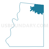
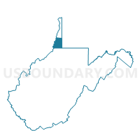
Voting District 38, Marshall County, West Virginia
About
Outline

Summary
| Unique Area Identifier | 691271 |
| Name | Voting District 38 |
| County | Marshall County |
| State | West Virginia |
| Area (square miles) | 22.86 |
| Land Area (square miles) | 22.71 |
| Water Area (square miles) | 0.15 |
| % of Land Area | 99.34 |
| % of Water Area | 0.66 |
| Latitude of the Internal Point | 39.98215390 |
| Longtitude of the Internal Point | -80.57193790 |
Maps

Graphs
Select a template below for downloading or customizing gragh for Voting District 38, Marshall County, West Virginia


Neighbors
Neighoring Voting District (by Name) Neighboring Voting District on the Map
- Voting District 146, Ohio County, WV
- Voting District 29, Marshall County, WV
- Voting District 35, Marshall County, WV
- Voting District 36, Marshall County, WV
- Voting District 39, Marshall County, WV
- RICHHILL TWP Voting District, Greene County, PA
- WEST FINLEY TWP VTD 01, Washington County, PA
Top 10 Neighboring County Subdivision (by Population) Neighboring County Subdivision on the Map
- District 1, Ohio County, WV (16,752)
- District 1, Marshall County, WV (10,892)
- Richhill township, Greene County, PA (896)
- West Finley township, Washington County, PA (878)
Top 10 Neighboring Unified School District (by Population) Neighboring Unified School District on the Map
- Ohio County School District, WV (44,443)
- Marshall County School District, WV (33,107)
- McGuffey School District, PA (12,757)
- West Greene School District, PA (5,108)
Top 10 Neighboring State Legislative District Lower Chamber (by Population) Neighboring State Legislative District Lower Chamber on the Map
- State House District 50, PA (59,028)
- State House District 49, PA (58,268)
- State House District 2, WV (34,538)
- State House District 4, WV (33,317)
Top 10 Neighboring State Legislative District Upper Chamber (by Population) Neighboring State Legislative District Upper Chamber on the Map
- State Senate District 46, PA (235,908)
- State Senate District 2, WV (101,327)
- State Senate District 1, WV (95,975)
Top 10 Neighboring 111th Congressional District (by Population) Neighboring 111th Congressional District on the Map
- Congressional District 18, PA (653,385)
- Congressional District 1, WV (615,991)
- Congressional District 12, PA (612,384)
Top 10 Neighboring Census Tract (by Population) Neighboring Census Tract on the Map
- Census Tract 208, Marshall County, WV (4,741)
- Census Tract 213, Marshall County, WV (4,454)
- Census Tract 9704, Greene County, PA (4,290)
- Census Tract 7960, Washington County, PA (3,375)
- Census Tract 22, Ohio County, WV (2,823)
Top 10 Neighboring 5-Digit ZIP Code Tabulation Area (by Population) Neighboring 5-Digit ZIP Code Tabulation Area on the Map
- 26003, WV (43,002)
- 26059, WV (3,082)
- 26033, WV (3,044)
- 15376, PA (1,740)
- 15377, PA (724)
- 26036, WV (425)